Hi, I have a need to set ImageRasterizer's ground extents based on one of the DWG layers bounding box! Is it possible? Please tell me so! It's a deal breaker for me to decide if FME is usable for us.
Best answer by takashi
View original
Hi, I have a need to set ImageRasterizer's ground extents based on one of the DWG layers bounding box! Is it possible? Please tell me so! It's a deal breaker for me to decide if FME is usable for us.
Best answer by takashi
View original
 +17
+17
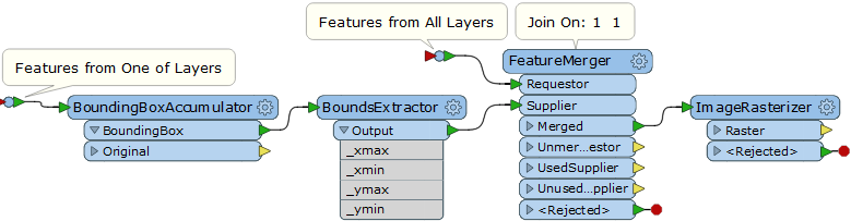
Hi @theodolite3, you can use the BoundingBoxAccumulator to create the bounding box enclosing all features in the layer and extract its extents (xmin, ymin, xmax, ymax) with the BoundsExtractor. Then, merge the extents attributes to all the features unconditionally with the FeatureMerger (set an identical constant e.g.1 to the Join On parameter), send the Merged features to the ImageRasterizer, and set the extents to the Ground Extents parameters.
This screenshot illustrates my intention.
It's working!! Big thank you!!!
Enter your username or e-mail address. We'll send you an e-mail with instructions to reset your password.
