Question

Projecting XY AutoCAD data to Lat Long using a Geographic Marker

  • 15 August 2018
  • 4 replies
  • 6 views

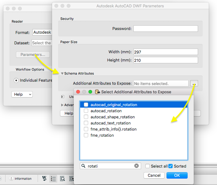
We have a number of AutoCAD files that contain geographic information through a Geographic Marker placed in the file. The geographic marker contains enough information to project the XY data into latitude and longitude, but I cannot work out how to access the XY position of the marker, nor the rotation of the XY axis from North (these are embedded in the AutoCAD file). Any help describing how I can reproject the AutoCAD files to lat long (for output to GeoJSON eventually) is greatly appreciated.

Thanks!


4 replies

Badge +2

Hi @natelampe,

You can select additional attributes to expose in the AutoCAD reader under Parameters > Schema Attributes. I would expect one of these parameters to match the XY attributes - perhaps the autocad_normal_x/y or autocad_original_position_x/y and there are also some different rotation attributes here:

If these are not in the desired CoordinateSystem you can then use a Reprojector transformer before writing out to GeoJSON.

Thanks for the reply. Unfortunately, all these attributes are empty in my file.

I think the problem is that FME is not picking up on the geographic information stored in the AutoCAD file (inside the AcDbGeoData object in the file). I am using the ACAD reader (not REALDWG, as I am working on Linux). Is this reader able to detect embedded geodata?

Badge +2

Thanks for the reply. Unfortunately, all these attributes are empty in my file.

I think the problem is that FME is not picking up on the geographic information stored in the AutoCAD file (inside the AcDbGeoData object in the file). I am using the ACAD reader (not REALDWG, as I am working on Linux). Is this reader able to detect embedded geodata?

Hi @natelampe,


Ah I see, it doesn't look like the AutoCAD reader is able to detect the embedded geodata at this time. However from a little research it seems like this geodata is stored in XML, in which case one route to try would be an XML based reader. Would it be possible to share a sample of the data you are working with and I can investigate whether this can be done in FME? You can share it on here or if you would prefer the data not to be publicly accessible you can Report a Problem and reference this post.


Thanks @hollyatsafe, I have submitted a report (C138792).

Reply