
I have a dwg file that I'm converting to a KML File. As you see in the attached work space the line features that are routed to the Utility_Lines KMLStyler have a label. Everything works great until I route them through a KMLRegionSetter then they stop showing. If I set GeometryFilter_2 to route the lines and arcs past the KMLRegionSetter they will show again. What could be the problem? There must be a setting somewhere to make this work.

Sorry I forgot to attach files

 +4
+4
@djcad do you mean that if lines and arcs are sent through the KMLRegionSetter_2, you do not see them in GoogleEarth application or there is no output from FME?
I tried passing the lines and arcs through KMLRegionSetter_2 as well as KMLRegionSetter_3 and was able to see the output.
happy fme-ing :-)
srg
@srg
Sorry for being unclear, The lines and arcs show but their label is missing. If you will bypass the KMLregionsetter you will see what I mean.
+4
@djcad
Thanks for the clarification.
I reviewed your workspace and noticed that the KMLStylers you have used for styling linear features have the default setting of Create Labels on Lines set to No.
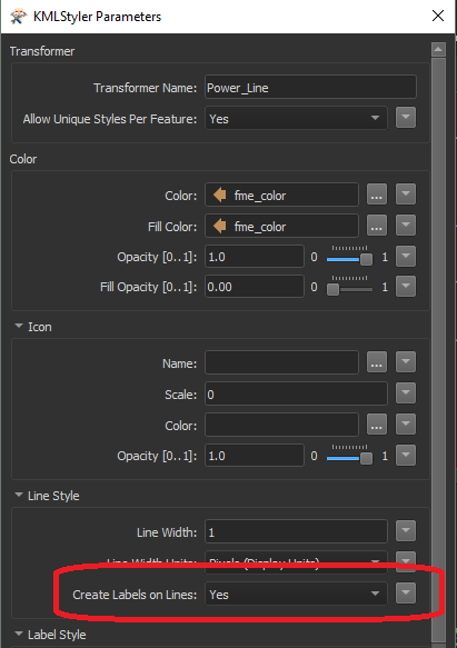
I changed them to Yes and was able to see the labels for linear features in GoogleEarth.
Try at your end and let me know if it works!
happy fme-ing :-)
srg
@srg Thanks for looking into this. My FME software is down for a few days so give me some time before I get back to you.
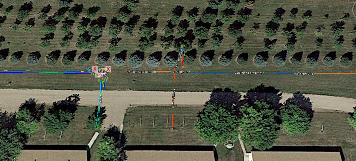
@srg 21240-sample.dwg 21239-sample.fmw Take a look at this. The KML Stlyer named Utility_Lines processes the lines that should show a label. The Labels do not show in Google Earth.
But If you'll filter them past the KML_regionSetters they will show without a problem.
+4
@srg 21240-sample.dwg 21239-sample.fmw Take a look at this. The KML Stlyer named Utility_Lines processes the lines that should show a label. The Labels do not show in Google Earth.
But If you'll filter them past the KML_regionSetters they will show without a problem.
@djcad
Okay I got it.
Apparently adding the Region to the Placemark doesn't correctly enable the labelVisibility mode in the line style when the feature becomes active. This is a bug in Google Earth. LabelVisibility works only if you don't use a Region.
You can get around this, by adding a Point within a MultiGeometry to the placemark to active with Region. Having a point enables the label to be displayed and the label is displayed at the location of the point.
Check this article:KML Line Label Visibility
hope that helps
happy fme-ing :-)
srg
Reply
Enter your username or e-mail address. We'll send you an e-mail with instructions to reset your password.