Question

How to clip with multiple clippers that overlap without merging outputs


Badge
Hi All,


I have had the joy of having 4 wisdom teeth removed this morning.... And in the process they have removed most of my GIS wisdom. They traded it for Good drugs thou... Anyways my brain is mush so i though you guys could help....


I have 20 school point features and a road centreline dataset. I want to sum the kms of road centreline contained within 2km radius of each of the 20 school individually (each school has a name field) . i have tried clipping the centerline by buffered schools but where the buffers overlap my output centreline file is missing roads.  for example the output should contain more roads than the input because 2 schools use the same road twice because they are within each others buffer. 


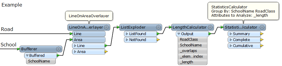
I have tried using the clipper with a group by on the school name but this causes no outputs from the clipper, I have tried a line on area overlay but have had similar results. Does anyone have any suggestions or steps im missing here. 


ps. hopefully when the codine wears off, my GIS brain will return. 


Thanks Steve

4 replies

Userlevel 2
Badge +17
Hi Steve,


Maybe this approach works.


1) Use the SpatialRelator or the NeighborFinder to transfer school name(s) to road lines which are within 2km distance from the school point(s).


2) Use the ListExploder to create copies of the road lines for every school related to the road.


3) Then, apply the Clipper with grouping by school name.


Takashi
Badge +3
Hi,


If u use a clipper for that, clipping is  a once process. Duplicate clipping will therefore not work, as the road will be consumed.


Like Takashi said, u need to duplicate the road lines based on the overlapcounts. (related)


Without the need to duplicate objects:


to extract the info you want  use a LineOnAreaOverlayer. Tester for overlaps >0  and do a statisticscalculator on the @length of roads grouped by Areas (schoolnames)


Badge
Many Thanks to you both. The list exploder helped me achieve what i needed plus a bit of arcgis and access for the group by queries.... I know fme could do it but i couldnt figure it out. 


I couldnt work out how to get the statisticsCalculator to group by a school and by the 5 road classes i had, (ie major, rural, arterial, mway) then sum the individual road class lengths. i used access to do a group by query of  school and  "road class" then sum on length.


Thanks again, for all your assistance. 


Steve
Userlevel 2
Badge +17
If the road lines have an attribute storing road class name (e.g. RoadClass), you can specify both school name and road class to "Group By" of the StatisticsCalculator to sum road lengths separately by road class.


And, maybe Gio's approach (LineOnAreaOverlayer) is more efficient than mine.


Reply