
Opening WFS data inFME loses geographical coordinates present in database and geometry type info?

Opening WFS data inFME loses geographical coordinates present in database and geometry type info?


Userlevel 1
 +10
+10
- Safer
- 371 replies
-
14 April 2020

Thanks for your question @ppp19! Are you able to provide a bit more information of what you are experiencing? Screenshots and examples always help.
Thanks for your question @ppp19! Are you able to provide a bit more information of what you are experiencing? Screenshots and examples always help.
Hi @nampreetatsafe,
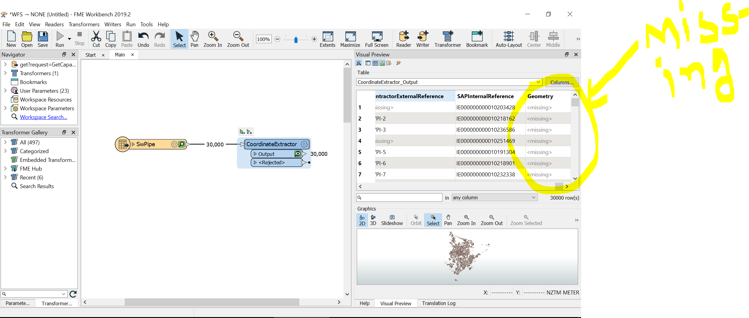
I am new to use FME. I have WFS data with 11 layers from a council. I want to read it in FME with geometry type and XYZ co-ordinates of all layers. I tried to read the WFS file using FME reader and using co-ordinate extractor to extract co-ordinate type which is not working according to my requirement.


Userlevel 1
 +12
+12
- Contributor
- 218 replies
-
15 April 2020

You are using Christchurch City Council WFS? If so, you should change to WFS 2.0, you need to set your maximum features to 100,000 for SW Pipe to get all the features, and it looks like your SRS axis needs changing to 2,1 to make the data project correctly. What is the url of the CCC WFS you are using?
As for your original question, the inspector is showing the geometry on the map and the coordinate system (NZTM) is also visible. So the data has both. What are you aiming to do?
If you want the GML geometry in a field, you can use GeometryExtractor set to the gml type you want, and probably omit the xml Namespace declarations
Cheers,
Todd
Userlevel 1
+12
- Contributor
- 218 replies
-
15 April 2020
You are using Christchurch City Council WFS? If so, you should change to WFS 2.0, you need to set your maximum features to 100,000 for SW Pipe to get all the features, and it looks like your SRS axis needs changing to 2,1 to make the data project correctly. What is the url of the CCC WFS you are using?
As for your original question, the inspector is showing the geometry on the map and the coordinate system (NZTM) is also visible. So the data has both. What are you aiming to do?
If you want the GML geometry in a field, you can use GeometryExtractor set to the gml type you want, and probably omit the xml Namespace declarations
Cheers,
Todd
cccwfs.fmw Here is a basic example of getting all the SwPipes and have the geometry stores as GML (although it is likely FME has other processes to acieve the outcome you really want)
 +8
+8
- Safer
- 350 replies
-
15 April 2020
Hi @ppp19
Can you elaborate bit more on the intended output?
Are you referring to FeatureInformation Windows which contains CoordinateSystem and Coordinates information?
If yes, please ensure that the open the window from Data Inspector --> View --> Windows --> FeatureInspector window
Do you want to extract the geometry? @todd_davis workspace does that to some extend.
There are other methods to achieve that as well if you want the coordinate or points extracted from each line feature (using VertexCreator etc) or if you want to calculate the length.
You are using Christchurch City Council WFS? If so, you should change to WFS 2.0, you need to set your maximum features to 100,000 for SW Pipe to get all the features, and it looks like your SRS axis needs changing to 2,1 to make the data project correctly. What is the url of the CCC WFS you are using?
As for your original question, the inspector is showing the geometry on the map and the coordinate system (NZTM) is also visible. So the data has both. What are you aiming to do?
If you want the GML geometry in a field, you can use GeometryExtractor set to the gml type you want, and probably omit the xml Namespace declarations
Cheers,
Todd
Hi @todd_davis,
thank you so much for your help. It worked well to collect CCC WFS format data to open and play with it in FME for me. Really appreciate your help on this.
A quick question: Why do we have to change SRS axis to 2,1 instead on 1,2 ?
I guess changing it to 2,1 format collects my data in co-ordinate format (y,x) instead of (x,y). Can you explain a bit more on this?
Regards,
Purvi
Hi @ppp19
Can you elaborate bit more on the intended output?
Are you referring to FeatureInformation Windows which contains CoordinateSystem and Coordinates information?
If yes, please ensure that the open the window from Data Inspector --> View --> Windows --> FeatureInspector window
Do you want to extract the geometry? @todd_davis workspace does that to some extend.
There are other methods to achieve that as well if you want the coordinate or points extracted from each line feature (using VertexCreator etc) or if you want to calculate the length.
Hi @rahulsharma,
Thanks for your reply on this. With your reply and suggestion from todd_davis...I am now able to collect and format my data in a way I want it to be.... :)
Regards,
Purvi
Userlevel 1
+12
- Contributor
- 218 replies
-
17 April 2020
Hi @todd_davis,
thank you so much for your help. It worked well to collect CCC WFS format data to open and play with it in FME for me. Really appreciate your help on this.
A quick question: Why do we have to change SRS axis to 2,1 instead on 1,2 ?
I guess changing it to 2,1 format collects my data in co-ordinate format (y,x) instead of (x,y). Can you explain a bit more on this?
Regards,
Purvi
Hi @ppp19,
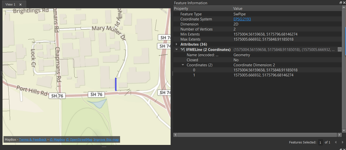
The service I sent through had a SRS axis on 1,2 (so x,y) but I noted the screenshot in your original post that the data did not look correctly projected (I could immediately tell that was Christchurch flipped) and I know from experience, some are set as 2,1 at the Christchurch City Council via WFS. So that was the reason I mentioned 2,1.
So you do want it to always be x,y, but sometimes that GML feed will come as y,x and it will depend of how they have setup the WFS service.
Cheers,
Todd
Userlevel 1
+12
- Contributor
- 218 replies
-
17 April 2020
Hi @todd_davis,
thank you so much for your help. It worked well to collect CCC WFS format data to open and play with it in FME for me. Really appreciate your help on this.
A quick question: Why do we have to change SRS axis to 2,1 instead on 1,2 ?
I guess changing it to 2,1 format collects my data in co-ordinate format (y,x) instead of (x,y). Can you explain a bit more on this?
Regards,
Purvi
In relation to the first image....you can see the estuary is in the top-left, but it should be bottom-right.
Hi @ppp19,
The service I sent through had a SRS axis on 1,2 (so x,y) but I noted the screenshot in your original post that the data did not look correctly projected (I could immediately tell that was Christchurch flipped) and I know from experience, some are set as 2,1 at the Christchurch City Council via WFS. So that was the reason I mentioned 2,1.
So you do want it to always be x,y, but sometimes that GML feed will come as y,x and it will depend of how they have setup the WFS service.
Cheers,
Todd
Thanks @todd_davis. It really make sense to me know.
Regards
Purvi
Reply
Enter your username or e-mail address. We'll send you an e-mail with instructions to reset your password.