
I am trying to translate a SHP file with NAD83 coordinates in meters to MIF/MID LL WGS84 degree data. Is this possible?


Userlevel 4
 +30
+30
- Evangelist
- 1874 replies
-
27 September 2017

Hi @sharon,
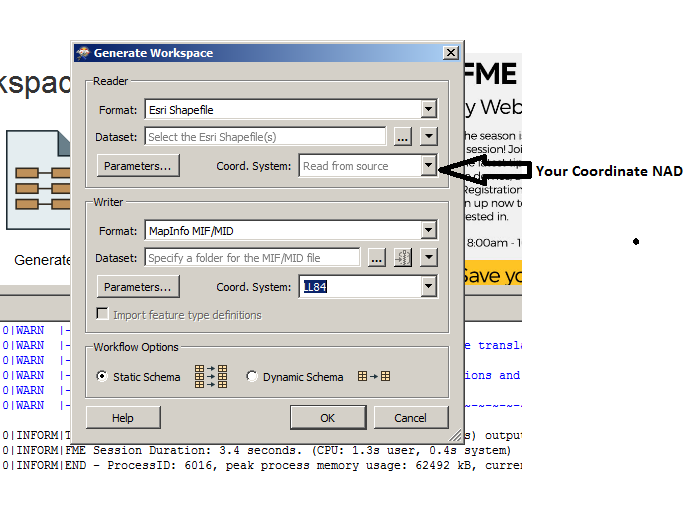
Have you tried to Generate Workspace:
Thanks,
Danilo

 +10
+10
- Safer
- 365 replies
-
27 September 2017

Hi @sharon
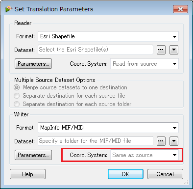
You can certainly do this kind of transformation from a SHP to MIF/MID while also transforming the coordinate system. When you generate a workspace, you can specify the coordinate system for both the reader and writer. You can see this in the screenshot from @danilo_inovacao
Alternatively, you could also use the Reprojector or Csmapreprojector transformer in between your SHP reader and MIF/MID writer where you would specify the source and destination coordinate system.
Hope this helps! - Andrea
Userlevel 4
+30
- Evangelist
- 1874 replies
-
27 September 2017
Hi @sharon
You can certainly do this kind of transformation from a SHP to MIF/MID while also transforming the coordinate system. When you generate a workspace, you can specify the coordinate system for both the reader and writer. You can see this in the screenshot from @danilo_inovacao
Alternatively, you could also use the Reprojector or Csmapreprojector transformer in between your SHP reader and MIF/MID writer where you would specify the source and destination coordinate system.
Hope this helps! - Andrea
Thank you Danilo.
My problem is with the meters unit that does not get translated to degrees. Where do I configure that?
Userlevel 4
+30
- Evangelist
- 1874 replies
-
28 September 2017
Thank you Danilo.
My problem is with the meters unit that does not get translated to degrees. Where do I configure that?
In Navigator option you can set the coordinate system.
Could you send me a sample of data?
Thanks,
Danilo
Userlevel 4
+30
- Evangelist
- 1874 replies
-
28 September 2017
Thank you Danilo.
My problem is with the meters unit that does not get translated to degrees. Where do I configure that?
Userlevel 4
+30
- Evangelist
- 1874 replies
-
30 September 2017
Between Reader and Writer you can use first a transformer Reprojector and configure to convert to NAD83 Degrees. So, use again the Reprojector and the configuration: NAD83 to LL84.
Did you test with these two transformers Reprojector?
Thanks,
Danilo
Thank you for your help and attention! This is my data, I tried the list of transformers but could not find a meter to degree transformer. Do you have a screenshot of the transformer that I should choose from the Workbench?
routes-fleettrack-sept2017.xmlDanilo,
The only piece of data I can send is an XML file. I don't know if this is helpful/
Userlevel 4
+30
- Evangelist
- 1874 replies
-
1 October 2017
routes-fleettrack-sept2017.xmlDanilo,
The only piece of data I can send is an XML file. I don't know if this is helpful/
Is your data the file Routes_FleetTrack_2.shp? Could you share this data?
Thanks,
Danilo

Userlevel 2
 +17
+17
- Contributor
- 7538 replies
-
1 October 2017

Hi @sharon, I think FME can recognize the coordinate system defined in the Shapefile data. Firstly, to confirm that, try inspecting the data with FME Data Inspector. If FME was able to recognize the coordinate system, its name would be displayed on the Feature Information window when you select a feature on the View, and also you can see its properties by clicking the coordinate system name.
If you were able to confirm that FME read the coordinate system definition from the source Shapefile data correctly, you can just set your desired destination coordinate system name (e.g. LL84) to the Coordinate System parameter in the Writer. That's it. FME transforms the data from the source coordinate system to your specified destination coordinate system automatically as far as FME supports both coordinate systems, regardless of what the units of the source/destination coordinate system were. Alternatively, as @AndreaEAtSafe suggested, you can also use the CsmapReprojector transformer to convert the source coordinate system (<Read from feature>) to any destination coordinate system (e.g. LL84) in the workflow. If you convert the coordinate system with the transformer, you don't need to set the destination coordinate system to the Writer.Hi @sharon, I think FME can recognize the coordinate system defined in the Shapefile data. Firstly, to confirm that, try inspecting the data with FME Data Inspector. If FME was able to recognize the coordinate system, its name would be displayed on the Feature Information window when you select a feature on the View, and also you can see its properties by clicking the coordinate system name.
If you were able to confirm that FME read the coordinate system definition from the source Shapefile data correctly, you can just set your desired destination coordinate system name (e.g. LL84) to the Coordinate System parameter in the Writer. That's it. FME transforms the data from the source coordinate system to your specified destination coordinate system automatically as far as FME supports both coordinate systems, regardless of what the units of the source/destination coordinate system were. Alternatively, as @AndreaEAtSafe suggested, you can also use the CsmapReprojector transformer to convert the source coordinate system (<Read from feature>) to any destination coordinate system (e.g. LL84) in the workflow. If you convert the coordinate system with the transformer, you don't need to set the destination coordinate system to the Writer.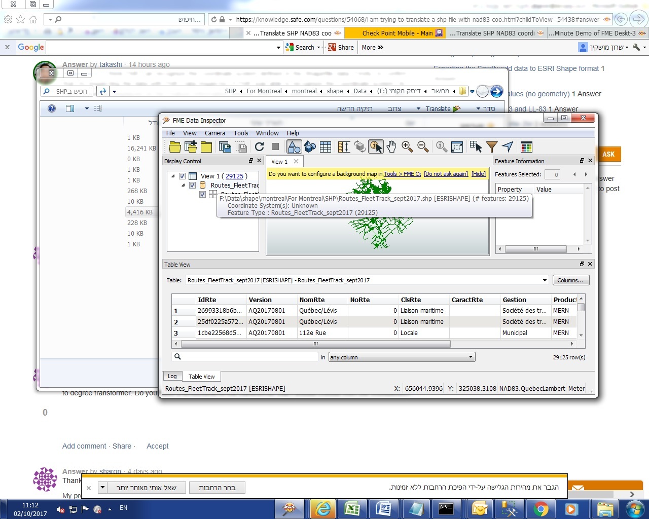
Userlevel 2
+17
- Contributor
- 7538 replies
-
2 October 2017
Hi @sharon, I think FME can recognize the coordinate system defined in the Shapefile data. Firstly, to confirm that, try inspecting the data with FME Data Inspector. If FME was able to recognize the coordinate system, its name would be displayed on the Feature Information window when you select a feature on the View, and also you can see its properties by clicking the coordinate system name.
If you were able to confirm that FME read the coordinate system definition from the source Shapefile data correctly, you can just set your desired destination coordinate system name (e.g. LL84) to the Coordinate System parameter in the Writer. That's it. FME transforms the data from the source coordinate system to your specified destination coordinate system automatically as far as FME supports both coordinate systems, regardless of what the units of the source/destination coordinate system were. Alternatively, as @AndreaEAtSafe suggested, you can also use the CsmapReprojector transformer to convert the source coordinate system (<Read from feature>) to any destination coordinate system (e.g. LL84) in the workflow. If you convert the coordinate system with the transformer, you don't need to set the destination coordinate system to the Writer.
OK. Thank you for that tip. Now I see the coordinate system.
I just tried the T
Userlevel 2
+17
- Contributor
- 7538 replies
-
2 October 2017
OK. Thank you for that tip. Now I see the coordinate system.
I just tried the T
In general, you can just select your desired destination coordinate system in the Coord. System parameter when adding the writer,
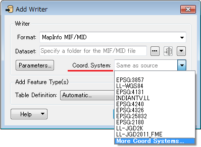
or the Coordinate System parameter of the writer on the Navigator window after adding the writer.
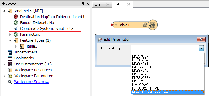
If required coordinate system name cannot be found in the drop down list of the parameter field, click the bottom-most "More Coord Systems" to open the Coordinate System Gallery. You can then search and select your desired coordinate system from the gallery.
Userlevel 2
+17
- Contributor
- 7538 replies
-
2 October 2017
OK. Thank you for that tip. Now I see the coordinate system.
I just tried the T
Thank you for your patience!
From the beginning I have chosen the projection that I want : LLWGS84. This is the result of the translation:
"
Opened mapping File C:/Users/user/AppData/Local/Temp/fme_gq5872.fme for output
Mapping File Generation was SUCCESSFUL
Mapping File Generation was SUCCESSFUL
FME Session Duration: 0.8 seconds. (CPU: 0.4s user, 0.2s system)
END - ProcessID: 5736, peak process memory usage: 74244 kB, current process memory usage: 74244 kB
Reading file
FME 2017.1.0.0 (20170731 - Build 17539 - WIN32)
FME_HOME is 'C:\\apps\\FME\\'
FME Database Edition (node locked-crc)
Serial Number: 0
Temporary License: 23 days left.
Machine host name is: Sharon
START - ProcessID: 9508, peak process memory usage: 31480 kB, current process memory usage: 31428 kB
FME Configuration: Command line arguments are `C:\\apps\\FME\\fme' `C:\\Users\\user\\AppData\\Local\\Temp\\fme-control-lY5872.tmp' `LOG_STANDARDOUT' `YES'
Shared folders for formats are : C:\\apps\\FME\\datasources;C:\\Users\\user\\Documents\\FME\\Formats
Shared folders for transformers are : C:\\apps\\FME\\transformers;C:\\Users\\user\\Documents\\FME\\Transformers
Shared folders for coordinate systems are : C:\\Users\\user\\Documents\\FME\\CoordinateSystems
Shared folders for coordinate system exceptions are : C:\\Users\\user\\Documents\\FME\\CoordinateSystemExceptions
Shared folders for coordinate system grid overrides are : C:\\Users\\user\\Documents\\FME\\CoordinateSystemGridOverrides
Shared folders for CS-MAP transformation exceptions are : C:\\Users\\user\\Documents\\FME\\CsmapTransformationExceptions
Shared folders for transformer categories are : C:\\Users\\user\\Documents\\FME\\TransformerCategories
FME Configuration: Reader Keyword is `ESRISHAPE'
FME Configuration: Writer Keyword is `MIF'
FME Configuration: Writer Group Definition Keyword is `MIF_DEF'
FME Configuration: Reader type is `ESRISHAPE'
FME Configuration: Writer type is `MIF'
FME Configuration: Destination coordinate system set to `LL-WGS84'
Coordinate System `LL-WGS84' parameters: CS_NAME=`LL-WGS84' DESC_NM=`WGS84 Lat/Longs' DT_NAME=`WGS84' GROUP=`LL' MAP_SCL=`1' PROJ=`LL' QUAD=`1' SCL_RED=`1' UNIT=`DEGREE'
FME Configuration: Current working folder is `F:\\Data\\shape\\montreal\\For Montreal\\SHP'
FME Configuration: Temporary folder is `C:\\Users\\user\\AppData\\Local\\Temp', set from environment variable `TEMP'
FME Configuration: FME_HOME is `C:\\apps\\FME\\'
FME Configuration: FME_BASE is 'no'
FME Configuration: FME_MF_DIR is 'C:\\Users\\user\\AppData\\Local\\Temp\\/'
FME Configuration: FME_MF_NAME is 'fme-control-lY5872.tmp'
FME Configuration: FME_PRODUCT_NAME is 'FME(R) 2017.1.0.0'
System Status: 337.13 GB of disk space available in the FME temporary folder (C:\\Users\\user\\AppData\\Local\\Temp)
System Status: 4.00 GB of virtual memory available
Operating System: Microsoft Windows 7 64-bit Service Pack 1 (Build 7601)
FME Platform: WIN32
Locale: he_IL
Code Page: 1255 (ANSI - ?????)
FME Configuration: Process limits are 3.95 GB of physical memory and 4.00 GB of address space
FME Configuration: Start freeing memory when process usage exceeds 2.37 GB of memory or 3.41 GB of address space
FME Configuration: Stop freeing memory when process usage is below 1.78 GB of memory and 2.56 GB of address space
Creating writer for format: MapInfo MIF/MID
Creating reader for format: Esri Shapefile
Using Shape Reader to read shape files from folder `F:\\Data\\shape\\montreal\\For Montreal\\SHP/'
ESRISHAPE Reader: Using enhanced geometry
Shape Reader: Using simple donut geometry detection
Shape Reader: Allowing attribute names with mixed case
Opened Shape File 'F:\\Data\\shape\\montreal\\For Montreal\\SHP\\Routes_FleetTrack_sept2017.shp' for input
Opened DBF File 'F:\\Data\\shape\\montreal\\For Montreal\\SHP\\Routes_FleetTrack_sept2017.dbf' for input
DBF Reader: Detected character encoding `utf-8'
DBF File 'F:\\Data\\shape\\montreal\\For Montreal\\SHP\\Routes_FleetTrack_sept2017.dbf' has fields: IdRte char(32), Version char(10), NomRte char(60), NoRte double, ClsRte char(50), CaractRte char(40), Gestion char(254), Producteur char(64), IdProduct char(36), Type short
Predefined coordinate system `NAD83.MTQ/Lambert' (Ministry of Transport of Quebec / NAD83 Lambert) matches dataset coordinate system
The OGC definition of the FME coordinate system '_NAD83.MTQ/Lambert_0' is 'PROJCS["Conique_conforme_de_Lambert_du_MTQ_utilis_e_pour_Adresse_Qu_bec",GEOGCS["GCS_North_American_1983",DATUM["D_North_American_1983",SPHEROID["Geodetic_Reference_System_of_1980",6378137.0,298.2572221009113]],PRIMEM["Greenwich",0.0],UNIT["Degree",0.0174532925199433]],PROJECTION["Lambert_Conformal_Conic"],PARAMETER["false_easting",800000.0],PARAMETER["false_northing",0.0],PARAMETER["central_meridian",-70.0],PARAMETER["standard_parallel_1",46.0],PARAMETER["standard_parallel_2",50.0],PARAMETER["scale_factor",1.0],PARAMETER["latitude_of_origin",44.0],UNIT["Meter",1.0]]'
FME Configuration: Source coordinate system for reader ESRISHAPE[ESRISHAPE] set to `_NAD83.MTQ/Lambert_0' as read from input data
Coordinate System `_NAD83.MTQ/Lambert_0' parameters: CS_NAME=`_NAD83.MTQ/Lambert_0' DESC_NM=`Ministry of Transport of Quebec / NAD83 Lambert' DT_NAME=`NAD83' ESRI_WKT=`PROJCS["Conique_conforme_de_Lambert_du_MTQ_utilis_e_pour_Adresse_Qu_bec",GEOGCS["GCS_North_American_1983",DATUM["D_North_American_1983",SPHEROID["Geodetic_Reference_System_of_1980",6378137.0,298.2572221009113]],PRIMEM["Greenwich",0.0],UNIT["Degree",0.0174532925199433]],PROJECTION["Lambert_Conformal_Conic"],PARAMETER["false_easting",800000.0],PARAMETER["false_northing",0.0],PARAMETER["central_meridian",-70.0],PARAMETER["standard_parallel_1",46.0],PARAMETER["standard_parallel_2",50.0],PARAMETER["scale_factor",1.0],PARAMETER["latitude_of_origin",44.0],UNIT["Meter",1.0]]' GROUP=`CANADA' MAP_SCL=`1' MAX_LAT=`64.36666666666666' MAX_LNG=`-54.266666666666666' MIN_LAT=`43.233333333333334' MIN_LNG=`-82.7' ORG_LAT=`44' ORG_LNG=`-70' PARM1=`50' PARM2=`46' PROJ=`LM' QUAD=`1' SCL_RED=`1' SOURCE=`EPSG, V7.01, 3798' UNIT=`METER' X_OFF=`800000'
Using MIF Writer to write dataset `F:\\Data\\shape\\montreal\\For Montreal\\SHP'
Shape Reader: Bounding box of shapefile `F:\\Data\\shape\\montreal\\For Montreal\\SHP\\ROUTES_FLEETTRACK_SEPT2017' is: (678600.791716085,283148.871088554),(729079.456999459,331482.84)
Shape Reader: Bounding box of shapefile(s) selected from folder `F:\\Data\\shape\\montreal\\For Montreal\\SHP/' is: (678600.791716085,283148.871088554),(729079.456999459,331482.84)
DBF Reader: Replaced non-numeric value for numeric field with default '0'
FME Configuration: Using FME Reprojection Engine
CS-MAP Reprojector: Transformation will be automatically selected for '_NAD83.MTQ/Lambert_0' -> 'LL-WGS84', and is not guaranteed to remain the same in future releases of FME
Reprojector: Using transformation `NAD83_to_WGS84,Forward(Null,EPSG:1188)' when reprojecting from _NAD83.MTQ/Lambert_0 to LL-WGS84
Opened MIF File F:\\Data\\shape\\montreal\\For Montreal\\SHP\\Routes_FleetTrack_sept2017.mif for output
Write with windows-1252 encoding from user input
Opened Separated Value File F:\\Data\\shape\\montreal\\For Montreal\\SHP\\Routes_FleetTrack_sept2017.mid for output with delimiter `,'
Unable to close output MIF file `F:\\Data\\shape\\montreal\\For Montreal\\SHP\\Routes_FleetTrack_sept2017.mif'
Unable to output feature data to file F:\\Data\\shape\\montreal\\For Montreal\\SHP\\Routes_FleetTrack_sept2017.mif
FME Session Duration: 0.9 seconds. (CPU: 0.5s user, 0.2s system)
END - ProcessID: 9508, peak process memory usage: 83144 kB, current process memory usage: 83144 kB
Unable to output feature data to file F:\\Data\\shape\\montreal\\For Montreal\\SHP\\Routes_FleetTrack_sept2017.mif
Program Terminating
Translation FAILED.
Translation failed"
this is the jist of the translation result:
"
Reprojector: Using transformation `NAD83_to_WGS84,Forward(Null,EPSG:1188)' when reprojecting from _NAD83.MTQ/Lambert_0 to LL-WGS84
Opened MIF File F:\\Data\\shape\\montreal\\For Montreal\\SHP\\Routes_FleetTrack_sept2017.mif for output
Write with windows-1252 encoding from user input
Opened Separated Value File F:\\Data\\shape\\montreal\\For Montreal\\SHP\\Routes_FleetTrack_sept2017.mid for output with delimiter `,'
Unable to close output MIF file `F:\\Data\\shape\\montreal\\For Montreal\\SHP\\Routes_FleetTrack_sept2017.mif'
Unable to output feature data to file F:\\Data\\shape\\montreal\\For Montreal\\SHP\\Routes_FleetTrack_sept2017.mif
"Any ideas??
Userlevel 2
+17
- Contributor
- 7538 replies
-
2 October 2017
this is the jist of the translation result:
"
Reprojector: Using transformation `NAD83_to_WGS84,Forward(Null,EPSG:1188)' when reprojecting from _NAD83.MTQ/Lambert_0 to LL-WGS84
Opened MIF File F:\\Data\\shape\\montreal\\For Montreal\\SHP\\Routes_FleetTrack_sept2017.mif for output
Write with windows-1252 encoding from user input
Opened Separated Value File F:\\Data\\shape\\montreal\\For Montreal\\SHP\\Routes_FleetTrack_sept2017.mid for output with delimiter `,'
Unable to close output MIF file `F:\\Data\\shape\\montreal\\For Montreal\\SHP\\Routes_FleetTrack_sept2017.mif'
Unable to output feature data to file F:\\Data\\shape\\montreal\\For Montreal\\SHP\\Routes_FleetTrack_sept2017.mif
"Any ideas??
Thank you for that idea. Except that I was able to translate to the same location previously and the results I got was in meters, which is not the result that I needed. I will try to obtain degree data and try again.
Thank you do much for your help!
Takashi,
Thank you so much for your help and precious time!!
In the end you were right, I did have a writing issue, which I resolved, and somehow the coordinates did come out in degrees after several attempts.
Thanks so much to all!!
Userlevel 4
+30
- Evangelist
- 1874 replies
-
2 October 2017
Takashi,
Thank you so much for your help and precious time!!
In the end you were right, I did have a writing issue, which I resolved, and somehow the coordinates did come out in degrees after several attempts.
Thanks so much to all!!
Reply
Enter your username or e-mail address. We'll send you an e-mail with instructions to reset your password.