Solved

Comparing LAS (pointcloud) files

  • 30 August 2017
  • 7 replies
  • 23 views

Badge

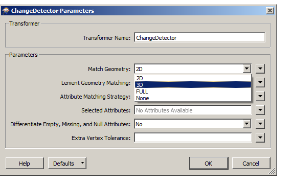
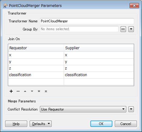
Hi, I have 2 LAS (pointcloud) files that have differences in classification of the points into different classes. What would be the quickest/easiest way to compare that files and output the differences into another LAS file please

icon

Best answer by danilo_fme 30 August 2017, 04:42

View original

7 replies

Userlevel 4
Badge +30

Hello @tadekfigura,

did you try use the transformer ChangeDetector? It is possible to compare 3D elements:

Thanks,

Danilo

Userlevel 4
Badge +30

Hi @tadekfigura,

I did search with more details in Safe Site and has the Webinar section.

In this section has a interesting Webinar How to Get the Most Out of LiDAR Data.

The transformer PointCloudMerger is good in your case. You can do download the Workspaces from this webinar above and see how can use it.

Documentation PointCloudMerger

Thanks,

Danilo

Userlevel 2
Badge +17

Are x, y, z components of all points in the second point cloud exactly equal to those of all points in the first point cloud?

Badge

Are x, y, z components of all points in the second point cloud exactly equal to those of all points in the first point cloud?

Yes the x,y,z, components are the same. The difference is only in assigning the points to different classes. For example in one file some points are in class "ground" in the other the same pointas are in class "vegetation". I want to get a new file cointationg only the difference in that case the vegetation that was classified from class ground.


Userlevel 2
Badge +17

Are x, y, z components of all points in the second point cloud exactly equal to those of all points in the first point cloud?

OK. I think the PointCloudMerger might help you. as @danilo_inovacao suggested.


For example, the transformer with this setting routes the points having the same classification to Merged and Referenced port, routes the points having different classification to NotMerged and Unreferenced port.


If you need to process only specific classes such as "ground" and "vegetation", you can use the PointCloudFilter to filter points within the source point clouds.


Badge

Thank you guys!

Userlevel 4
Badge +30

Thank you guys!

You are welcome @tadekfigura !


Good teamwork @takashi :)

Reply