Solved

Linear Referencing

  • 7 October 2013
  • 5 replies
  • 62 views

Hi All,


I have a table with a 'route_ID' and a measure value (like a event table). On the other hand I have a polyline feature classe.  The attribute 'Name' correspond to route_ID from the table. The measure values are points on the lines.


Now the measure values changed by a predetermined value (e.g. the point was 10 m and now the point is 10.5m). My Problem, the Polyline feature class is not defined as route form a linear referencing system. And so the table and the Polylines have no relations. I don't no where (which coordinate) my old and new points are.


Can I build a route feature class with FME? The Basisc should be my polyline Feature Class.


I would have assumed a route feature class, how can I creat points (with coordinates) form the table?


Thanks for your help.


Debby
icon

Best answer by david_r 7 October 2013, 11:12

View original

5 replies

Userlevel 4
Hi,


a route feature class (in ESRI-speak) is simply a polyline table with M-values at each vertex, so yes, you can create it using FME.


To apply measures (M-values) to your polyline, use the MeasureSetter. There is also the MeasureInterpolator and the MeasureOrZValueInterpolator in the FME Store that might help if you don't have M-values for all the vertices.


You will first have to find a way to connect your M-values to each polyline, though.


If you need to set the M-values for all the vertices of the polyline features, I'd do something like this:


Measures:


- ListBuilder with GroupBy on the Route_ID


- ListSorter on the M-values (increasing)


Polylines:


- FeatureMerger with the features containing the measure list (Name = Route_ID)


- MeasureSetter, type "whole line"


Finally, add a MeasureInterpolator, if needed.


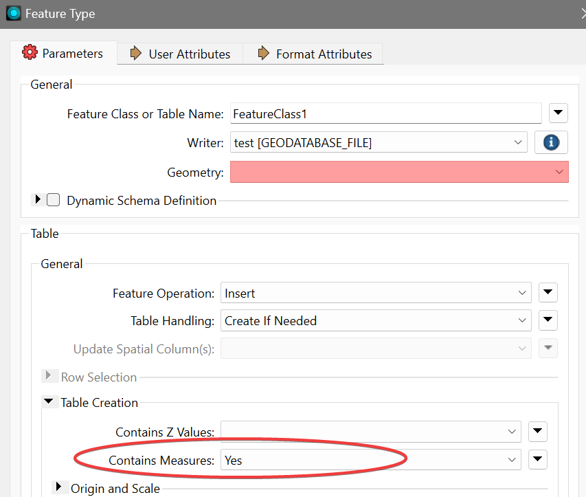
When writing the feature class, make sure that you enable "Contains measures" on the output feature format parameters.


David
Badge +7
Hi,


a route feature class (in ESRI-speak) is simply a polyline table with M-values at each vertex, so yes, you can create it using FME.


To apply measures (M-values) to your polyline, use the MeasureSetter. There is also the MeasureInterpolator and the MeasureOrZValueInterpolator in the FME Store that might help if you don't have M-values for all the vertices.


You will first have to find a way to connect your M-values to each polyline, though.


If you need to set the M-values for all the vertices of the polyline features, I'd do something like this:


Measures:


- ListBuilder with GroupBy on the Route_ID


- ListSorter on the M-values (increasing)


Polylines:


- FeatureMerger with the features containing the measure list (Name = Route_ID)


- MeasureSetter, type "whole line"


Finally, add a MeasureInterpolator, if needed.


When writing the feature class, make sure that you enable "Contains measures" on the output feature format parameters.


David

Hi @david_r​ ,


I know this is a decade old question but I am having difficulty in writing the M values to the shapefile.


I have a route with vertices at 1-meter interval. I used MeasureGenerator and is able to see the _measure values for each vertex. However, when writing to a shapefile, I get NaN for the M-value of each vertex while the M-value is totally missing when writing to a feature class in a file geodatabase.


Any ideas?


Many thanks,

Sig


Userlevel 4

Hi @david_r​ ,


I know this is a decade old question but I am having difficulty in writing the M values to the shapefile.


I have a route with vertices at 1-meter interval. I used MeasureGenerator and is able to see the _measure values for each vertex. However, when writing to a shapefile, I get NaN for the M-value of each vertex while the M-value is totally missing when writing to a feature class in a file geodatabase.


Any ideas?


Many thanks,

Sig


Not sure about the shape file, but if you're writing to an existing FGDB feature class, make sure that it allows M values:

https://pro.arcgis.com/en/pro-app/latest/help/data/feature-classes/defining-feature-class-properties.htm#GUID-8EE6F702-D419-4624-B28E-01FF08233871

I.e. this must be enabled on the feature class (disabled in the screenshot below), otherwise M values will not be stored:

imageIf you're creating the feature class with FME, be sure to enable the option on the writer:
image

Badge +7

This worked well, thanks @david_r. I was not seeing these options before since I was using an Open API writer.

Userlevel 4

This worked well, thanks @david_r. I was not seeing these options before since I was using an Open API writer.

For what it’s worth, the API writer also supports measures, but it’s a bit more obtuse about what it expects from you to trigger this behavior.

See https://docs.safe.com/fme/html/FME-Form-Documentation/FME-ReadersWriters/filegdb/Geometry-Support-filegdb.htm

Notably, I seem to remember that you have to leave the destination measure name empty in the MeasureSetter.

Reply